

Appalachian Trail
The start of the Appalachian Trail begins at the top of Springer Mountain in southern Fannin County where it begins…
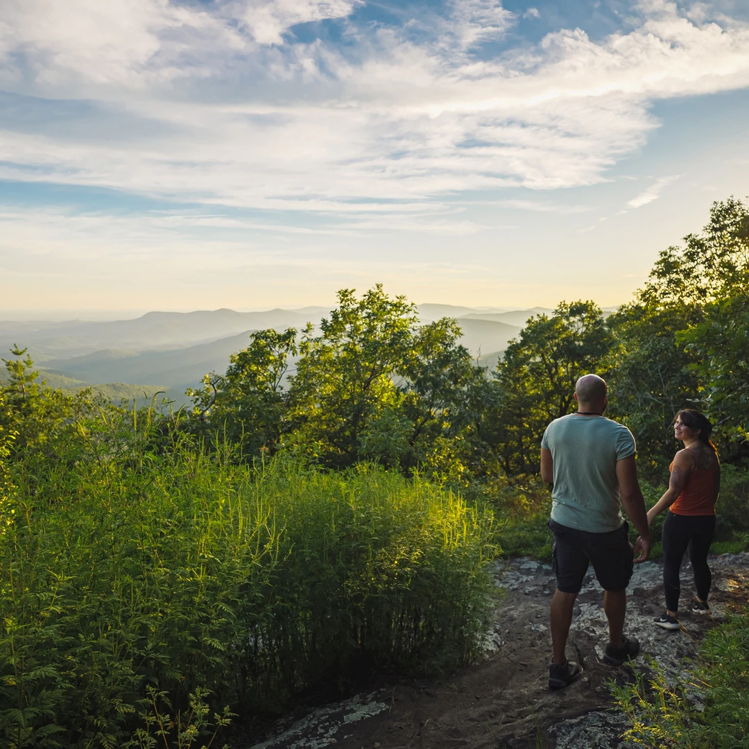
The Aska Adventure Area—a local favorite—is a hiking-mountain bicycling trail system 17.0 miles in length developed on National Forest lands near Deep Gap on the Aska Road in south central Fannin County.
Trails range in length from 1.0 to 5.5 miles and are open to the public year-round.
Trails ascend to near 3,200 feet, providing vistas of mountain ridges and descend to the shores of Lake Blue Ridge. They also pass through coves of mature hardwoods and thickets of laurel and rhododendron.
Two trails cross or travel along mountain streams providing a range of forested settings. Any time of the year is recommended for use. Hunting (large game, gun) season is generally late October through December 31. Stream water flow and wildflower displays are best in the spring. Winter days are often clear and cool with many delightful views of distant mountains.
Download our Aska Trails Self Guided Tour Guide for more information about access and trail difficulty ratings.
Trailheads are located at Deep Gap, Stanley Gap, Shady Falls Road and Forest Road 711 by way of Campbell Camp Road. Parking is free. Bulletin boards at trailheads show maps of the area and the trail system.

The Aska Trails system includes the following trails:
Distance: 5.5 miles
Type: Out and Back
Difficulty: Hard
Distance: 4.6 miles
Type: Out and Back
Difficulty: Moderate
Please note: 1.3 miles of the Upper Green Mountain Trail has been decommissioned.
Distance: 5.8 miles
Type: Loop
Difficulty: Moderate
Distance: 0.1 mile
Type: Out and Back
Difficulty: Moderate
Distance: 2 miles
Type: Loop
Difficulty: Easy
The main trailhead location is at Deep Gap, a short 15-minute drive from the Welcome Center. Three other trailheads are at Stanley Gap, Shady Falls Road, and on Forest Road 711 by way of Campbell Camp Road. Bulletin boards at trailheads show maps of the area, and the trail system.
Deep Gap - From McDonald's restaurant at intersection of GA Hwy. 515 and GA Hwy. 5 in Blue Ridge. Proceed east on GA Hwy. 515 (toward Blairsville) approx. 0.8 miles to Collins Avenue. At Collins Avenue turn right, go 0.2 miles to dead end with Old U.S. 76. Turn left, go 0.2 miles to Aska Road on right. Turn right, go south 4.4 miles to Deep Gap parking area below gap and on right side of road.
Stanley Gap - Go south on Aska Road 8 miles. Turn right on Stanley Creek Road (Toccoa Riverside Restaurant on left). Parking area for trail is 4.1 miles on right.
Forest Road 711 - Drive south on Aska Road 2.5 miles to Campbell Camp Road. Turn left and follow main road 0.8 miles to Forest Road 711 intersecting from left. Follow 711 past private homes; turn right, trailhead 2.0 miles.
Shady Falls - Follow Aska Road south 5.9 miles to Shady Falls Road. Turn left, go 0.2 miles, parking area on left.
Times can range from as short as 15-20 minutes to a 3-5 hour round trip hike or ride from one end of the system to the other. It is the various combinations of trails that provide the diversity of cycling and hiking experiences. See individual trail descriptions on trailhead boards for details of mileage, challenge, general layout and other unique features.

No motorized vehicles or pack stock, including horses, are allowed on the trail system. The trails have been designed and constructed for use by day hikers and mountain bicyclists.
Primitive camping is allowed anywhere in the national forest unless posted otherwise. Please, do not camp on private lands or within 50 feet of streams. Rules and regulations of the national forests apply to all recreational activities. Do not cut live trees, use dead and down wood only for campfires, do not pollute, bathe in, or contaminate streams and watercourses. Do not litter. If you pack it in, pack it out.
Yes, dogs are allowed on the trails, but they must be leashed.
Yes, there are plenty of ways to have fun and enjoy the Aska Adventure Area as a family. Bike the trails, hike the landscape, or explore the water!
No matter your recreation of choice, these are the must-haves you should be packing before a day out in nature along the Aska trails:
The Toccoa River Canoe Trail also runs through the Aska Trails Area. For detailed directions or more information, contact the Welcome Center or the USDA Forest Service at (706) 745-6928. And find more information about the Chattahoochee-Oconee National Forest through the U.S. Department of Agriculture's website.
Don't think you have to leave the comfort of your car to discover more of the Aska Adventure Park. See our Self-Guided Tours for scenic drives that feature the stunning natural sites throughout the area.
Appalachian Trail
The start of the Appalachian Trail begins at the top of Springer Mountain in southern Fannin County where it begins…

Benton MacKaye Trail
Blue Ridge is a Benton MacKaye Trail Town.
Chattahoochee National Forest
Fannin County has 106,000 acres of forest, 66,097 in the Blue Ridge Ranger District and 40,006 acres in the Cohutta Wilderness.

Cohutta Wilderness
With more than 40,000 acres in Georgia and Tennessee (where its known as Big Frog Wilderness Area), the Cohuttas comprise…

Swinging Bridge on the Toccoa River
The Toccoa River Swinging Bridge is a 270-foot bridge in Fannin County, Georgia—the longest swinging bridge east of the Mississippi…

Waterfall Hikes
Enjoy our local waterfalls and others nearby.
Big on Beauty, Low on Mileage: Fantastic Hikes under 2 Miles
Some of our favorite spots are tucked deep within remote wilderness areas.
This website uses cookies to optimize your visitor experience. Learn More